Melbourne to Esperance and return via Lake Eyre, 2011

Love the Gawler Ranges photos, having been there recently myself. Your comments seem spot on.

We also stayed in the chain wire enclosed CP in Ceduna (um, interesting place - the locals seemed surprised when we said 'hello' in the street). We had lunch at Fowlers Bay another day.
 
My apologies folks, I’ve been out and about lately, hence the delay. I’ll try to pick up where I left off.


To this point, Wahgunyah was easily the most remote beach location I had camped at.

Morning came and it was fresh and full of promise. After breakfast I climbed a dune to take in the surrounds once again.


0168imgp1995.jpg


0169imgp1998.jpg


I managed to get camp packed pretty quickly, and once on the limestone near the beach I took the time to air up the tyres. That done, I looked at the time and decide that it really was too nice a location to not have a swim. Before I got in I took some more pics including this one looking west.


0170imgp2002.jpg


While in the water, I was made to feel somewhat sick by the sight of a fin sticking out from the surface not too far from me. The Great Australian Bight is notorious for white pointer sharks, and my thoughts immediately turned to the logistics of driving a manual vehicle with one leg bitten off by a shark. Another fin appeared, and it didn’t take long for me to get onto the beach again.

Another fin appeared, and another. My heart rate slowed in the knowledge that the more fins I saw the less likely it was to be sharks. Besides, they weren’t going to get me on the beach.

It was with a sense of relief rather than foolishness that I came to the realisation that it was a pod of dolphins, and a large one at that. In clusters of fives and sixes I had soon counted past fifty as I trained my camera on them to try to catch their movement.


0171imgp2006.jpg


0172imgp2016.jpg


0173imgp2024.jpg


0174imgp2026.jpg


Some dived, others rolled and others still caught waves. Others did “flips ‘n ****” but I was not “On a Boat” and there were no other “muthafu^%ers” around.

Another spectacular show, and not another person in sight. Half an hour or so of exclusive morning entertainment that I will never forget.

I could have stayed, but today was to be special. My destination was planned well in advance: I was to travel to the Koonalda Cave which was 20,000 years ago a flint mine.

.../continues
 
Continued…

I retraced my route out of Wahgunyah and back to the highway towards Nundroo still marvelling at the size of the pod of dolphins I had just seen. As I write, I still feel that Wahgunyah was one of the highlights of the trip.

A head full of a rich experience has a way of disposing of many kilometres as if they were not there, and it seemed altogether too quick that I had reached the turnoff to the “Head of the Bight”. This is the northernmost bay of the Great Australian Bight, where in winter around 100 Southern Right Whales gather to breed and give birth, and about 15,000 tourists visit between June and October to take in the spectacle. By my standards it is a reasonably “touristy” location, replete with toilets, a visitor centre, viewing platforms and a rather large car park.

It was with a sense of self assigned intrepid superiority that I rumbled the Dulagarl into the carpark among the campervans and backpacker bombs, thinking as loudly as I could “yep, I’ve seen sh*t today that you bast%rds can only dream of…”. Off went the motor, out I got, and with camera, binoculars and a couple of muesli bars I set off towards the visitor centre. Intrepid indeed. I may have even had an apple.

I was fairly pleased to learn that the centre is an Indigenous owned and operated venture, situated as it is in the Yalata Indigenous Protected Area.

https://www.yalata.org/lands.htm

You are in Nullarbor central here, and the plain stops with no subtlety at all as it reaches the Bunda Cliffs which tower up to 70 metres above the sea.

I spent only a little time gaining a basic orientation of the vistor centre, determined to return before I set off west. The view out the window was simply too spectacular to not be drawn to and I was soon on the walkway to the viewing platform. Various plaques provided insights to the locale, including this one explaining some of the Anangu dreaming of the area…


0175imgp2039.jpg


Overlooking what it described.


0176imgp2040.jpg


0180imgp2055.jpg


I enjoyed the view with a Dutch couple who I had briefly met earlier along the road, making them jealous with my description of the dolphin pod at Wahgunyah. Being encumbered by a rather large campervan, they were unable to get to such a location as Wahgunyah, despite their wishes. They had in fact tried to get into Fowlers Bay but abandoned that endeavour for fear of the vehicle shaking apart, vowing to stick more closely to the bitumen.

We chatted and enjoyed the sheer grandeur before us, squinting into the distance towards Antarctica while breathing air that had been breathed by no-one else for thousands of kilometres as it wafted off the Bight.

0177imgp2041.jpg


The Bunda Cliffs looking to the west.

0178imgp2049.jpg


0179imgp2054.jpg


... continues
 
Last edited:
...Continued

The views and atmosphere are thought provoking to say the least. Satiated by the visuals, I felt ready to take on the visitors centre to provide some context and it didn’t disappoint.

Aside from a great description of the antiquity of the evidence of Anangu occupation of the region (finger engravings in the cave at Koonalda dated over 20,000 years old, and a flint tool of 36,000 years at Allen’s Cave further west), the centre gave an interesting sense of the layers of history of the Nullarbor.

I had never before the considered the role of the steam train in colonisation. But here it was described. To the north, Ooldea soak had for millennia provided an important source of water for Anangu travelling through their country.

A little bit of water goes a long way in these parts. In the 1960’s some old Anangu men described to a journalist how “old Mr Eyre” in 1840 (Edward John Eyre, who was in fact in his 20’s at the time) was helped to find water and grass as he travelled by horse from east to west. It is described in “Maralinga: the Anangu Story” as follows:

“having unsaddled the horses, we set to work to dig holes to water them; the sand however was very loose; and hindered us greatly. The natives…observed the difficulty under which we were labouring and one… who appeared to be the most influential… said something to two … upon which they got up and came towards us, making signs to use to get out of the hole, and let them in; having done so, one…jumped in, and dug in an incredibly short time, a deep narrow hole with his hands; then sitting so as to prevent the sand running in, he ladled the water out with a pint pot, emptying it into our bucket…held by the other native. As our horses drank a great deal, and the position of the man in the hole was… very cramped… the two natives kept changing places… until we had got the water we required.”​

It is probable that the location described was Ooldea soak which was visited by Venning and Howie in the 1870’s as they travelled sinking wells. Ernest Giles also went there in 1875, and used it as a base camp. Many others followed.

In 1901, while looking for a route for a railway to the West, JG Stewart, Government Surveyor, passed through Ooldea. The information centre at the Head of the Bight describes how between 1874 and 1876 the east – west telegraph line was built, following an ancient Aboriginal trade route through the area. It also describes th opening of the east west rail line in 1915. A display states:

“At Ooldea, which had been a major Indigenous trading centre, locomotives used 45,000 litres of water every day. In a few years this destroyed what had been a permanent source of water for Indigenous people.”

As all but one well at the soak failed by 1923, eight years of drought began. More Anangu became reliant on the soak as it became less reliable. Anangu were soon consigned to prostituting themselves to and begging from the people on the trains that had drunk their water dry.

Irony: As white people developed a technological means to travel through Anangu country, and hence to travel across the nation, Anangu lost the capacity to travel through their own country by traditional means.

As I wrote earlier: this aspect of steam trains had not previously occurred to me.

Returning to the highway, I found that there were numerous spots to pull in where the plain simply stopped, and the Bunda cliffs plunged away to the ocean.


0181imgp2066.jpg


0182imgp2067.jpg


It was disconcerting. I had no way of knowing precisely how much earth was under my feet: it could be only a matter of metres and below that an expanse carved out by the advancing ocean. I was wary of straying to close to the apparent edge, lest my weight cause the earth beneath me to create a new edge behind me.


0183imgp2069.jpg


I soon reached the turnoff to Koonalda: unmarked, but I was certain from the GPS that it was the turnoff that I wanted. Heading north away from the highway it soon became apparent that there was some sort of campsite nearby as evidenced by ever opportunist dingoes close by the track.


0184imgp2086.jpg


0185imgp2089.jpg


Numerous vehicle wrecks were close by the old homestead at Koonalda.


0186imgp2095.jpg


The day was close to an end, and while the homestead and the wrecks were very interesting, I couldn’t resist heading further north to get my first glimpse of the cave itself.


0187imgp2115.jpg


I determined to return to the cave in the morning for a better look with more favourable light. I headed back towards the homestead and set up camp by the shearing shed, some distance from the shearers’ quarters where two couple had established camp for the night.

Over dinner and a few beers, I began to hear the occasional dingo howl and see the occasional bat. A special little visitor was drawn to the LED lantern on the table.

0187aimgp2124.jpg


The photo doesn't really do it justice, but it is a praying mantis: not green or brown but a rich metallic gold colour. It had obviously adapted to reflect the strong sunlight of the Nullarbor, and I had never seen such a remarkable adaptation of a relatively common creature.

As I drifted off to sleep, my head was full of thoughts about how it came to me that 20,000 years ago this was a site of trade in flint, and wondering about the people who entered the dark cave to leave some of the oldest engravings and markings in the world.

I would not sleep well that night.
 
Last edited:
Sensational narration Greg, coupled with the fantastic photos and awesome adventures, it makes for riviting stuff
I think I've read through this thread about 15 times so far!!
 
Thanks for the reviews folks. It makes me happy that you like the story, it really does.

Here’s day 16…


Somewhere between day 15 and day 16, something went bang. Not just “bang”, but “BANG”, or perhaps more “BOOM”. Not just once either. A metallic, hollow percussive BOOM like a 44 gallon drum falling off a truck, or a door slamming on a galvanised iron garage.

I was soon wide awake, and it was still dark. Waking like that gets the heart rate going, and you wonder whether you dreamt the sound or whether it was real, and if it was real whether you would hear it again, and if you did whether it was a threat, and if it was what you would do and

BOOM, thump thump.

F*ck! I thought! What the?

Suddenly I remembered rabbits…

then dingoes…

then car wrecks.

The equation became obvious: Rabbit + car wreck / dingo chasing rabbit = BOOM squared.

Fu^&ers.

It was funny the first time, but it did wear thin after being repeated over a few hours in more than a few wrecked cars.

A light sleep can lead to a long sleep in, but when you have a hunger for your immediate environment it means rising early. Being only about 80km from the WA border, I was again a few degrees further west than the previous morning, and the sun took longer again to catch me and my body clock than the day before.

I think that I was out of the tent before the sun had hit my previous day’s camp at Wahgunyah.


0188imgp2125.jpg


There was the odd dingo paw print on my camping table, from where the odd curious dingo had tried to scavenge leftovers. I had been careful to not leave ANYTHING that would interest a dingo outside of my tent (NOTE: this includes dirty dishes, items of clothing, food scraps, boots etc. Don’t give the bast^rds a chance at anything!)


0189imgp2132.jpg


The dew sat heavily on the tent, almost as though it had rained. The early sun glistened off the car wrecks of Koonalda as though they all had new glossy paint jobs. They were so enticing that I decided to photograph EVERY car. I have included a selection here…


0190imgp2135.jpg


0191imgp2137.jpg


0192imgp2144.jpg


0193imgp2148.jpg


0194imgp2171.jpg


As I took in each car, it occurred to me that each one had a story, and I imagined the passengers and drivers of the past, and how that particular vehicle had carried them and their dreams and hopes to this remote outpost at a time that the roads were bulldust and limestone, and then stayed here, sometimes keeping those hopes and dreams with them as their occupants either returned home or pressed on.


0195imgp2182.jpg


0196imgp2192.jpg


Just as the cars had tried to claim the Nullarbor, and instead claimed the hopes of their drivers and passengers, the Nullarbor was now claiming the cars, slowly.


0197imgp2200.jpg


Here they were, arranged in little groups of Holdens and Fords, Austins and Chevrolets.

By itself, a 1970’s Valiant, seemingly as ostracised as a “new Australian” brickies’ labourer or concreter who may have once driven it in a far flung western suburb.


0198imgp2223.jpg


Reminiscent of the shooting scene in the Australian classic film “Wake in Fright” sat an old Holden modified with a roof turret for shooting while driving. A classic piece of ingenuity which, if it still worked, would have served to change the dynamic of the dingoes and rabbits of the night before.


0199imgp2235.jpg


(this youtube will give you some idea. The film was called “The Outback” when it was released in the USA)

[ame="https://www.youtube.com/watch?v=TQDZJnisNiY"]Wake In Fright (1971) - YouTube[/ame]


0200imgp2259.jpg


All brilliant photographic subjects, which I promise will form an exhibition one day. (Readers who can identify any of the car models in the pics, and their memories of that car, are encouraged to comment!)

It was time for breakfast, and then the cave.
 
Awesome photos!!!

I've got a thing for taking pictures of old cars/vehicles decaying in their final resting places.:cool:
 
Wow, those pics of the old cars, in their final resting places are fantastic :ebiggrin:

Regards
Mr Turbo
 
Dude this is a fantastic write up, reminds me very much of the joys and perils of traveling alone, your encounter with the dolphins that initially has had you thinking sharks and a one leg drive out of the bush to get help have enticed me to share with you all a trip last March to the Leiderderg (not far out of Melbourne)

It can all go wrong in the blink of an eye :iconwink:

Fortunately on this trip I had a friend with me and his car.

We had set up camp had a fire going and my daughters 3yrs and 5yrs were with me pottering around was a fantastic afternoon the dogs running around :)

My eldest daughter then told me she had business to do, so grabbed the shovel and off went up the nearest hill to find a suitable place to dig a hole.

Got the business sorted out and then thought we better see ho far up the hill we could go, so with shovel in one hand 3yr old in the other (always keen to join in an exploration) off we headed up the hill with my 5yr old streaking out in front. Got to the top and enjoyed the views over the bush, time to head back down to camp and put the lamb leg in the camp oven.

The hill was not particularly steep but covered in leaf litter and some gravel, now here I am about 500 meters out of camp up a non existent walking track with 2 young girls, my foot slips the little toe catches a rock and then promptly forces the outer three toes up under the other half of the foot length ways, while I try not to drop my 3yr old.

Needless to say there were many words that young children should never hear let out in conjunction with the audible snap of bones breaking. My 5yr old innocently asked me - what was that noise dad?

The next hour to get back to camp was needless to say painful and all I was thinking - thank god I brought an auto I can still drive out of here.

So a few words of caution - always have a back up plan you never know what might get you and when is normally when you least expect it.

1year on have lost the limp but still got foot pain and still thanking the foz for being an auto - (my mate I am sure would have driven me out if could not have)
 
Life got in the way of this blog for a while, but I am determined to finish it. In this instalment, day 16 continues.


koonaldaandregion.jpg


Over breakfast I took stock of exactly where I was. About 80 km west was the WA border, and less than 20 km south was the ocean. If I headed about 100 km north from here I would meet the Trans Australian Railway at Hughes: the last named location on the line before Western Australia.

Only about 6km north was the cave, and its lure was strong, even though I knew that I would not be able to enter and explore it. I got breakfast out of the way and headed north to contemplate and wonder.


0202imgp2318.jpg


I you look closely at the next image, you’ll see that the Dulagarl is dwarfed by the opening of the cave.


0203imgp2345.jpg


Radiocarbon dating of hearths in the cave shows that between 15,000 and 22,000 years ago, that this was a site of some activity. Early markings in the cave are thought to be about 20,000 years old, which places them among some of the oldest in the world (although others in France and Australia are thought to be as old as 30,000 years). The markings were found some distance from the cave, where there is no natural light. Archaeologists speculate that the cave was not so much occupied as mined, and of course the water supply was useful in an arid environment.

20,000 years ago, the Nullarbor was a different place. For a start, the coast was estimated to be significantly further south, placing the cave much further from any marine resources than it is now.

A link to an image of some of the early finger markings is here:

https://www.originsnet.org/koonaldagallery/pages/i)flutingwbc.htm

My head was full of questions: Was it the Mirning people who actually went into the cave to mine flint? The caves of the Nullarbor were thought by the Mirning to house evil spirits, and this is consistent with the hesitancy of other Indigenous people’s to enter dark caves. What did people believe about this place? What value was placed on the flint? How far was it traded? And the obvious question: what became of the Mirning people whose place this was?

I took a lot of photographs and thought a lot about the underground expanse: 60 metres below the surface and extending at least 250 metres and a large subterranean lake as yet not measured.

An enticing image of a lucky explorer on the underground lake is here:

https://farm4.static.flickr.com/3343/3181292449_9918825afc.jpg


I could have stayed there for weeks, and would love to return and explore the cave with the appropriate permission.

I headed back to the homestead, since I was yet to have a look at the buildings themselves.

The shearing sheds…


0204imgp2355.jpg


The scales


0205imgp2357.jpg


Inside the shearing shed


0206imgp2364.jpg


0207imgp2365.jpg


A I probably mentioned earlier, the homestead was actually on the old Nullarbor Hwy, as you can see from the map, and provided an opportune place for a roadhouse, and hence the wrecked cars.


0208imgp2367.jpg


(I doubt that the roadhouse has ever had a vehicle this good pull up there before!)


The homestead and some outbuildings, the one in the foreground reminiscent of wurley: the traditional shelter of the Mirning.


0201imgp2269.jpg


The shearers’ quarters


0209imgp2368.jpg


The homestead entrance


0210imgp2370.jpg


And what would a blog entry be without the obligatory photograph of an interpretive sign?


0211imgp2373.jpg


0212imgp2374.jpg


If you were wondering how anyone could get a sheep station to operate here, the sign has part of the answer: water was pumped from the underground lake in the cave.

Later, I was to read more about this as follows:

“The land between Nullarbor Station and the South Australian – Western Australian border was leased to various pastoralists until 1938 when Roy and Cyril Gurney made application to graze sheep on it. The request was refused owing to the lack of water. Undeterred, the brothers advised they could pump water from Koonalda Cave and in an extraordinary effort to prove this could be done lowered an engine, pumping equipment and piping into the cave. Subsequently in 1942, the lease was granted.”
(“The Nullarbor Plain – A History, Neville Collins, 2008)

I don’t think any government in 1942 would have worried too much about the long term viability of such an enterprise, nor about the cultural or environmental implications. There were other more pressing matters to worry about, so I suppose that’s how the Gurney’s got their way. More about them later.

The place hasn’t operated as a station since it was acquired in 1989 as part of the National Park. Fortunately, the place hasn’t been looted of all reminders of station life.


0213imgp2377.jpg


0214imgp2378.jpg


Old newspaper clippings from the 1960’s about Jackie Kennedy littered the floor of one of the rooms, and outdated price lists seemed to offer ridiculous bargains from the early days of decimal currency.

It was a rich experience to take in all of this alone: the various layers of history with their common element of supporting travel through harsh arid environs. Modern travellers leave surplus items such as canned food, the odd potato and condiments in the cupboard of the shearers’ quarters to sustain others in their journey.

(...continues)
 
Last edited:
(...continued)
It was time to go, and I chose to follow the old highway westwards for a way, before turning left to get back to the modern highway.


0215imgp2383.jpg


0216imgp2387.jpg


0217imgp2394.jpg


0218imgp2398.jpg


Once at the highway, there were numerous dirt tracks heading further south for short distances before they were terminated dramatically by the receding cliffs. Closer to the border, the cliffs were a little more gradual.


0219imgp2401.jpg


0220imgp2402.jpg


0221imgp2403.jpg


Somewhere just before the border I stopped at a wayside stop to organise some lunch, using the last of my fresh fruit and vegetables knowing that I would not be able to buy any until I reached Norseman over 700 km away. Rather than waste any produce at border quarantine, I ate all that I thought I had, only to have to later sacrifice a rogue tomato that escaped my attention.

It occurred to me that an industrious traveller could set up a produce stall just inside South Australia, collecting unwanted produce from west bound travellers and offering it to east bound travellers. If only I had the time…

With the formalities of border quarantine out of the way, I bought fuel at Eucla Roadhouse and paid a grossly inflated price for a can of cola, the brand of which doesn’t require any further advertisement from me. (Note: Fuel is actually cheaper at the border village than it is at Eucla).

I didn’t have a lot of time to spend, since I was intending to get as far as the Eyre Bird Observatory near Cocklebiddy by nightfall, and I still had 264 km to go.

Following signs to the old telegraph station, I drove down the escarpment.


0222imgp2410.jpg


At this part of the Nullarbor, the dramatic cliffs give way to a series of sandy beaches, while the cliffs recede inland forming the edge of the Nullarbor Escarpment, or “the scarp” for short. Below the scarp at this end is mallee vegetation and huge dunes. West of Eucla the Roe plains, sparsely vegetated, lie below the scarp.

I briefly wandered around some of the old telegraph station outbuildings.


0223imgp2413.jpg


0224imgp2414.jpg


0225imgp2416.jpg


0226imgp2418.jpg


0227imgp2419.jpg


Obviously, no expense was spared in housing the Trans Australian telegraph when it was first built. It was after all, a big deal to connect eats and west by a telegraph wire. (More about that later).

The state of the buildings, once so important to national trade, development and security, demonstrated that with technical advance there is necessarily obsolescence, and in this sense the buildings reminded me of so many tube type televisions discarded on roadsides: still in perfect working order, but no longer state of the art.

I motored on past Mundrabilla, and rested in the afternoon heat at a roadside stop near Madura. My slumber in my hammock was interrupted by the arrival of a rented Landcruiser with a young Irish couple accompanied by a Frenchman, who stopped to cook some excellent looking salmon steaks. We chatted, and I was somewhat bemused by their determination to get from Perth to Melbourne in 72 hours. So much for seeing Australia!

Near Madura, the country around the range was more densely vegetated, and looked an interesting habitat to explore.


0228imgp2424.jpg


It had been a long day, and I regretted having to go past to turnoff to the Eyre Bird Observatory to get fuel in Cocklebiddy, only to have to double back. Surprisingly, as I was refuelling a police car arrived, and I was glad that all this time I had not once broken the speed limit. Honestly!

I turned back to the turnoff to Eyre, and stopped by an information sign by the turnoff to establish how I would contact the caretakers to organise accommodation. I had not pre-booked, and was taking a risk, but the worst they could say was “no” I figured. I proceeded towards the coast, occasionally using the UHF to contact “Eyre Birds” as the sign had suggested.

I made it all the way to the “carpark” at the top of the escarpment before I succeeded in making radio contact. A polite exchange established that I would be welcome to arrive in the morning and that this evening I should double back a short distance and camp by a disused microwave tower. This I did, and established camp in a quite pleasant surround.

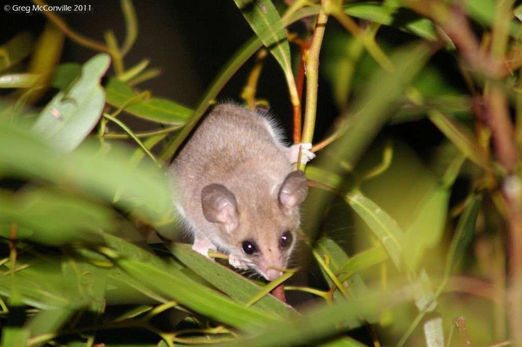
As I sat eating dinner in the dark I sensed a movement in a nearby Mallee tree, and luckily had my camera close by. A mouse sized marsupial, known as a Western Pygmy Possum, was feeding on new growth in the eucalypt. With much excitement I took a flash photograph, only to feel more than a slight sense of guilt at having blinded the poor little creature temporarily.


0229imgp2432.jpg


I promised myself that I would not do this again, and reconciled I slept with a sense of good fortune at having watched such a tiny and delicate creature. Day 16 started in South Australia, and finished in Western Australia.
 
Back
Top